
Professionalism. Excellence. Timeliness.
Fast, efficient, and honest, GEODESY DRONE SURVEYING CONSULTANTS has become a reputable and well-known Drone Surveying Brand. Our team is up for every job, managing projects with the skill and experience our clients have come to expect. We want our customers to be satisfied with our work, which is why we provide open communication channels throughout the duration of each project.
Mr Muni, Chief Advisor and Mentor, who has more than 30 years of experience, has established a name in the field of Land Survey, and has formed strategic partnerships with clients, will provide geodesy with the best advice and help. His administrative and executive abilities will support the company's expansion plan. INS Kadamba or Project Seabird for the Indian Navy facility in Karwar, the survey of the swimming pool for the Commonwealth Games 2010, and the Karnataka State Cricket Association (KSCA) stadium (Chinnaswamy Stadium), Bangalore, are a few of the major projects Mr. Muni has worked on and managed.

Mr Sampath Arumugam, Chief Consultant and Chartered Engineer, has extensive expertise and experience in the field of infrastructure projects. He has experience working for the Government of Assam as the Managing Director/Project Directors for the Guwahati Metropolitan Drinking Water Supply & Sewerage Board and the Water Supply & Sewerage Projects. He also has 34 years of experience working for L&T - Construction as the Project Director/Joint General Manager, 3 years of experience working for Tata Projects as the General Manager - Operation, and nearly 1 year working for the Government of Assam as the Managing Director for Jal Board/Project Directors for Water & Sewerage Projects. We are fortunate to have him work with us as the chief consultant because he has experience handling a wide range of pipeline projects, including Survey (conventional, LIDAR & Drone, DGPS, Total Station & Levels), DPR works and other related techno-economic analysis, those involving as well as industrial projects of any kind.

Mr Suges Muniyandi, our founder is a MSc Mechanical Engineering Design graduate from The University of Manchester. He is a DGCA certified Drone Pilot from the Telangana State Aviation Academy. In addition to this, he has also completed a Diploma course in Drone surveying and Mapping from Khagolam institute of Geoinformatics, Mumbai and worked as Head of Operations for Hawking Robotics and Technology Private limited, Chennai.

Professional drone services specialising in aerial topographic survey data collection. Survey your site or project with the latest best-in-class technology. Aerial survey methods are safer and cost-efficient. Survey outputs are comprehensive, accurate and still provide traditional CAD drawings in addition to the detailed point-cloud and 3D models generated by drone surveys.
We use the latest RTK positioning technology onboard our state-of-the-art surveying drones and ground control points to tie in our data in even tighter. Our drone surveys are ultra-accurate, proven down to 2 cm in horizontal and vertical direction.
Our topographical surveys help you understand the area of land you have to work with. We will identify the exact position of features, ground levels in the surveyed area, building footprints and remnants.
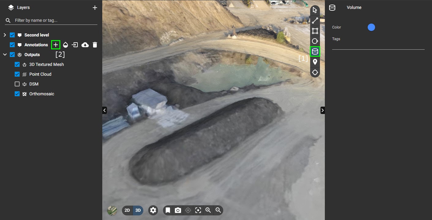
This type of survey details accurate measurements of stockpiles of earthworks, and quantifies the volume of material stockpiled on-site. Also used in quarry operations, it gives an accurate indication of current activities and helps to calculate the amount of extracted or stockpiled materials.
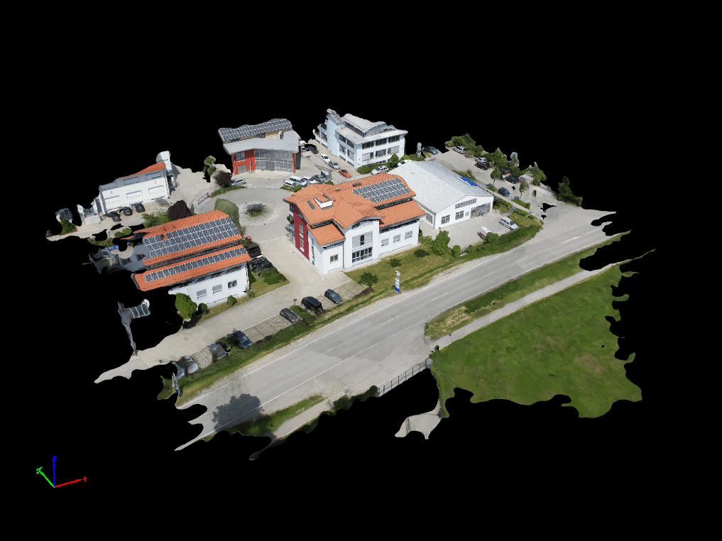
Our high-resolution cameras take clean, crisp images. We then turn these images into realistic 3D models using a process known as photogrammetry. This aligns all of the images, stitches them all together, georeferences each individual pixel and then creates a point cloud from the pixels. As the x, y and z of each pixel is known, we can then carry out measurements of 3D assets, land and stockpiles.
The resulting 3D model or map is a permanent record of the surveyed area, allowing for easy reference and comparison over time. This can be valuable for applications such as monitoring the changes in an area, tracking the progress of a construction project, or detecting changes in natural resources.

Development in drone technology has changed outlook of project monitoring. Our drone survey-based project monitoring solution helps client to measure the progress such as the percentage of earthwork completed, amount of black topping completed, milestones achieved with respect to deadlines and report to the clients such as the project developer, nodal consultant, project management consultant and the Government bodies.

Acquisition of data digitally permits powerful software processing that delivers required outputs much faster than traditional methods. Our survey results can often be delivered within just a few days. We use professional data processing software for obtaining the output as per the client’s requirements. We can process data for you or hand over raw data for you to process using your own systems.
Up to date data of your site in various formats and media. Incredibly visual and accurate data makes planning and site management efficient. Point-clouds can be imported into your software of choice.
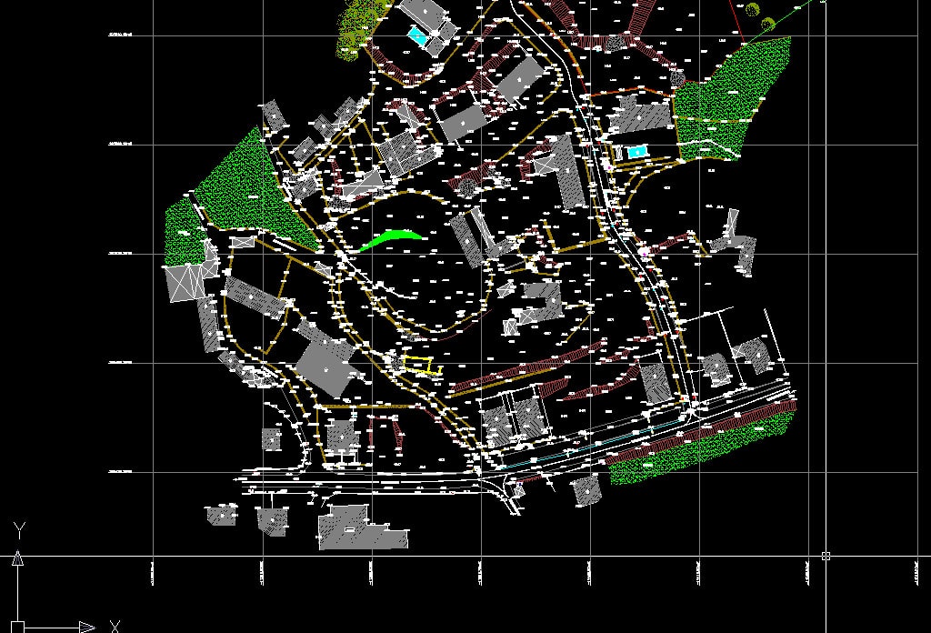
Despite modern drone and laser survey point-clouds supplying an all-encompassing view of your survey which you can interact with and analyse efficiently either online via cloud tools or on your engineering workstation, our clients most often, and with very good reason, also require traditional 2D drawings of the survey.
2D survey drawings remain the de facto format to exchange and refer to for a large number of companies, suppliers and contractors within the life cycle of operations within any construction, civil engineering or property development project.
Output delivered by us